
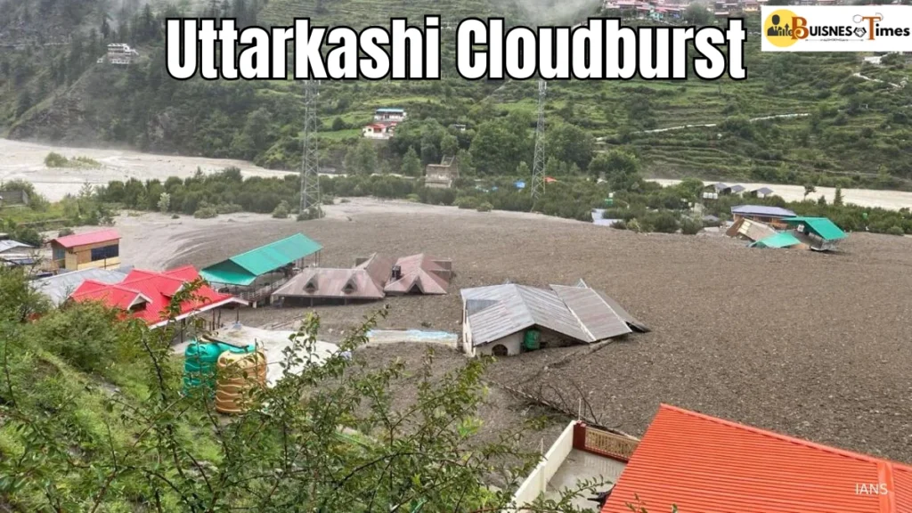
A tragic cloudburst triggered flash floods and landslides in Uttarkashi district, Uttarakhand, on Tuesday, resulting in at least five fatalities and dozens reported missing. In Dharali village near Harsil, homes, hotels, and even sections of an army camp were swept away by a violent surge of mud and water. With entire structures buried and hazardous terrain hampering rescue operations, officials warn that up to 100 individuals may still be buried under debris.
The Dangerous Geography of Uttarkashi
Rugged Himalayan Topography
Located deep within the Garhwal Himalayas, this region is defined by steep slopes, unstable rock formations, and fast-moving glacier-fed rivers. These conditions create a perfect storm for landslides, flash floods, and debris flows, especially during monsoons.
Glacier-Fed Rivers & Narrow Valleys
Rivers like the Bhagirathi, Alaknanda, Mandakini, Dhauliganga, and Yamuna wind through tight valleys. During heavy rainfall and rapid glacial melt, they swell significantly, often bursting their banks and triggering sudden floods Uttarkashi. When combined with unchecked deforestation and infrastructure development, the fragile Himalayan terrain turns dangerously unstable.
Uttarkashi River Sources and Vulnerable Villages
The Bhagirathi & Devprayag
Originating at Gaumukh, the snout of the Gangotri Glacier at roughly 4,000 meters, the Bhagirathi River is deeply revered in Hindu tradition. It flows through Gangotri, Harsil, and Uttarkashi, collecting major tributaries like Jadh Ganga, Kedar Ganga, and Bhilangna, before meeting Alaknanda at Devprayag to form the sacred Ganga.
While Alaknanda carries a larger water volume, Bhagirathi holds religious significance as the true source of Ganga.
Dharali Village
Perched at about 2,680 meters above sea level, Dharali lies along NH‑108 (Gangotri Road)—just 6 km from Harsil, and 14 km before Gangotri. Surrounded by pine and deodar forests, it sits above the Bhagirathi riverbed, yet remains vulnerable to flash-flood surges and rockfalls.
Mukhba (Mukhimath)—“Ganga’s Maternal Home”
At 2,620 meters, Mukhba serves as the winter worship place for devotees of Goddess Ganga. The statue from Gangotri is relocated here when snowfall blocks roads. Local tradition holds it as the goddess’s maternal home, active from Diwali through spring.
Logistics: How Remote the Region Is
Distance & Connectivity
Dharali is roughly 78–99 km from Uttarkashi town, depending on the route. A drive from Dehradun to Harsil via NH‑34 takes 6–7 hours, and from Delhi, it spans 440–480 km, typically requiring 7–12 hours on the highway.
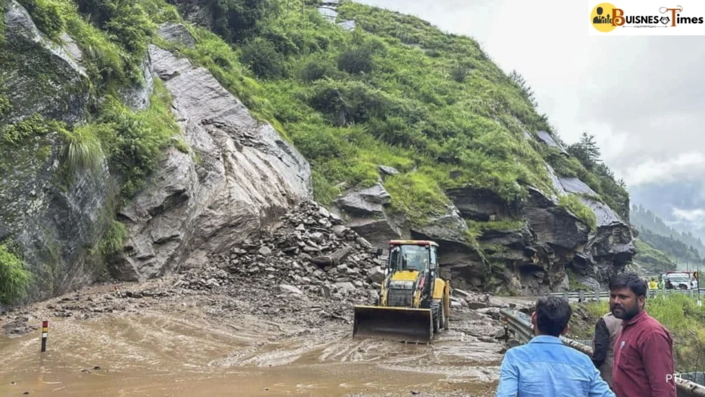
Access Road Fragility
Most roads are narrow and hug steep slopes, making them easily disrupted by landslides and flood debris. During emergencies like this cloudburst, even the best rescue teams struggle to reach affected zones due to blocked or eroded roads.
Why the Hills Fail: A Mix of Nature and Human Impact
Terrain Vulnerability
Landslides occur because the slopes are geologically young and unstable. Rock plates easily break off during heavy rain or seismic activity. When water floods these slopes, it loosens sediment and triggers high-velocity debris currents.
Climate Factors at Play
Rising temperatures have accelerated glacial melting, which adds to river volume. Combine it with intense monsoon rainfall, and rivers can swell rapidly—turning a stable landscape into disaster zones within hours.
Human Interference
- Deforestation for agriculture or development
- Road construction destabilizing slopes
- Unregulated building in flood-prone zones
All of these reduce natural buffers and amplify the impact of extreme weather events.
Eyewitness Accounts: Disaster Through Local Eyes
Survivors describe sudden onset of flooding. One resident recalled being on their terrace when torrents of water and mud washed away nearby hotels and homes—some structures disappeared entirely.
Access to basic communication was lost quickly as mobile towers failed. In the chaos, families scrambled for safety. Reports indicate no prior warning, and many families were unintentionally left in the open during local rituals or regular daily life.
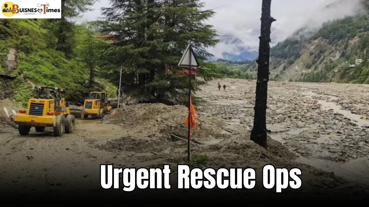
Response Efforts & Rescue Challenges
- Rescue forces from NDRF, ITBP, and Uttarakhand State Disaster Response teams are engaged in search operations.
- Helicopters and drones assist in locating survivors where ground access is impossible.
- Remote terrain makes clearing blocked routes difficult, delaying essential supplies.
- Temporary camps have been set up further downriver, offering shelter and medical care to displaced residents.
- Screening for waterborne diseases and mental health support are ongoing priorities.
How Uttarkashi Can Avoid Future Disasters
Early Warning Systems
Advanced rainfall alerts, river-level sensors, and fast-response communication networks are critical. Reducing warning-to-impact time could save lives in future events.
Sustainable Infrastructure
Instead of building perilously near riverbanks or steep slopes, planners should adopt resilient engineering, proper drainage, and bans on high-density structures in high-risk zones.
Reforestation
Replanting trees—especially deep-rooted native species—can stabilize soil, reduce landslides, and diminish runoff during heavy rains.
Awareness & Community Training
Local programs should educate communities on recognizing early signs of cloudbursts and evacuation protocols to reduce panic and improve response.
Regulating Tourism & Development
Since Char Dham pilgrimage traffic and commercial tourism escalate during certain seasons, unregulated construction and high footfall must be managed with care and planning.
Uttarkashi in Context: A Himalayan Case Study
Uttarakhand isn’t alone in facing such hazards. Across the Himalayas—from north Nepal to Kashmir and Bhutan—extreme weather events are becoming more severe. However, Uttarkashi’s combination of steep terrain, fragile geology, expanding tourism, and climate change makes it particularly vulnerable.
Global reports cite that Himalayan glacial and rainfall patterns have intensified over the past two decades, increasing the frequency of flash floods in high-altitude river valleys. Infrastructure planners and government agencies are now under pressure to prepare for amplified risk scenarios.
The Human Toll and Urgent Rescue Response
As the waters surged through Uttarkashi’s serene mountain villages, panic gripped the locals. Families were torn apart in seconds, homes crumbled, and livelihoods were swept away. In Dharali and surrounding areas, terrified villagers described the deafening roar of water, rocks, and mud as they scrambled to escape. Eyewitness accounts paint a chilling picture of nature’s fury, with buildings collapsing like dominoes and people vanishing into the raging flood.
Rescue operations have been launched by the National Disaster Response Force (NDRF), State Disaster Response Force (SDRF), and the Indian Army. Helicopters and sniffer dogs are being deployed, but relentless rain and blocked access routes are making the task more dangerous and time-consuming. Emergency shelters have been set up, and hundreds have been evacuated to safer zones.
Experts warn that these events may become more frequent due to climate change, unchecked urbanization, and deforestation in ecologically fragile zones like Uttarkashi. Authorities are urging people living near vulnerable zones to remain alert and prepared, as the weather forecast predicts more rain in the coming days.
This disaster once again highlights the urgent need for sustainable development and early-warning systems in India’s Himalayan belt — where beauty meets brutality with little warning.
Understanding Risks to Build Resilience
In Uttarkashi, nature’s force was swift and merciless. But the geography—its rivers, slopes, and high-altitude ecosystems—did not act alone. It was a combination of climate shifts, fragile terrain, and unchecked development that turned a rainstorm into a catastrophe.
As rescue operations continue, the region must also invest urgently in preparedness—embedding early warnings, sustainable planning, and community training into its recovery blueprint. Only through understanding the science of the terrain and human responsibility can Uttarakhand hope to turn a tragedy into a lesson in resilience.